
By Bob Grainger –
For years, residents of McKellar Park have been unearthing golf balls when they dig in their gardens. They are relics from the past, as over 60 years ago the entire neighbourhood was occupied by McKellar Park Golf Club.
The golf course opened in 1928. Many of the members and the casual players would arrive on the Ottawa Electric Railway streetcar (along what is now Byron Avenue) and walk up Windemere Avenue to the clubhouse. The minutes from the annual shareholders meeting in the spring of 1929 noted they had 400 members and work was underway to make further improvements to the course. These same minutes also indicated the following: Miss Bertha Cowan was elected President of the Ladies’ Section; Mr. W.A. Smith won the Club Championship that year; and Mr. Ernie Wakelam accepted the invitation to become the club’s first pro.
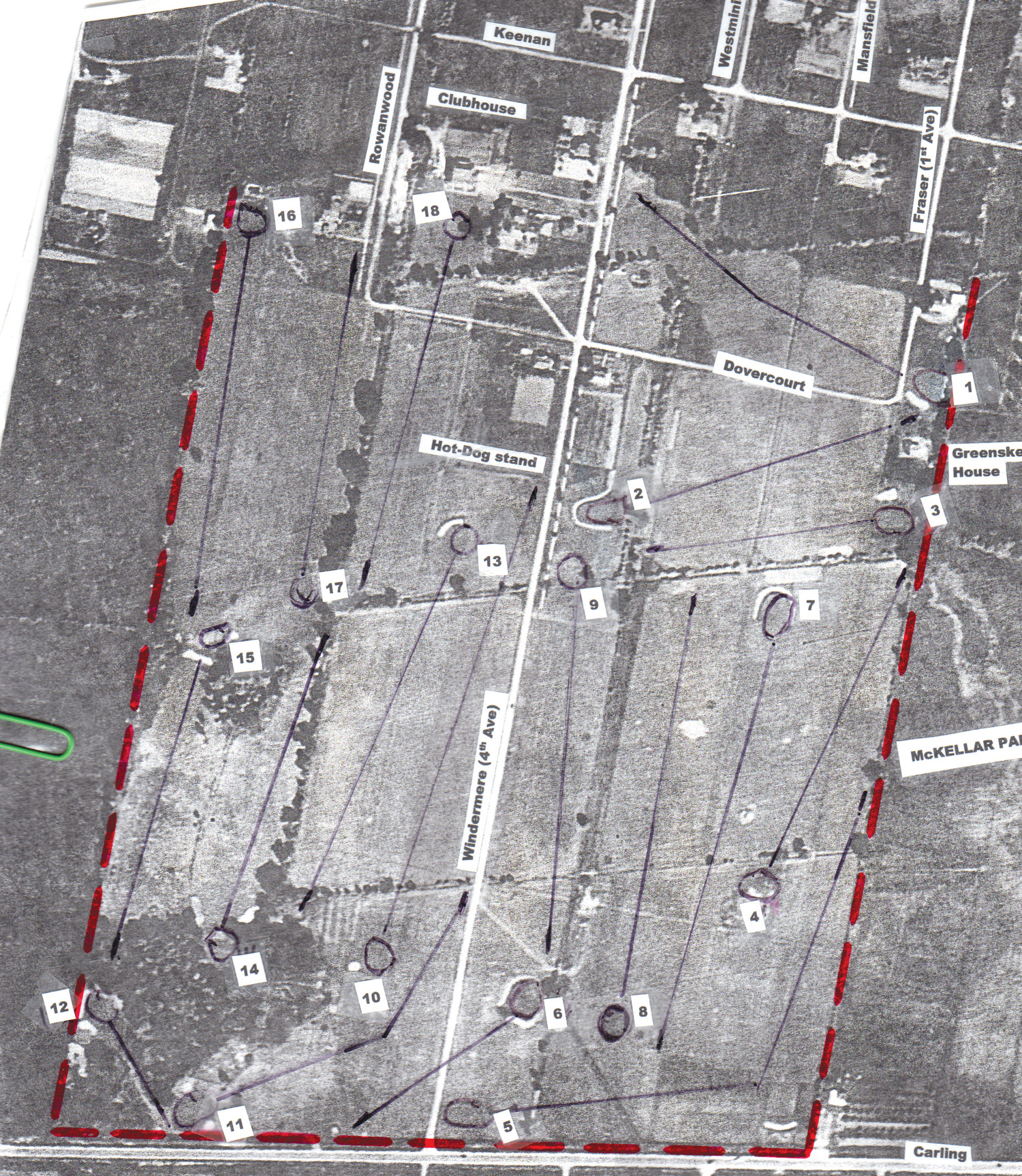
It was, for the most part, a thriving operation, and was considered an enjoyable and challenging course. The golf course had a length of more than 6000 yards and played to a par of 70 for the men. In the aerial photo above, the numbers from 1 to 18 indicate the location of the different greens, and a dark line from the tee to the green shows the fairway. The clubhouse was located just to the east of the 18th green, where other golfers and spectators could watch from the verandah with a cold drink in hand as fellow members finished their round.
Today, this clubhouse would have been located on the west side of Gainsborough Avenue, about halfway between Dovercourt and Keenan. There is no current sign of the clubhouse, but some excavations this past summer unearthed a foundation that is thought to have belonged to the clubhouse.
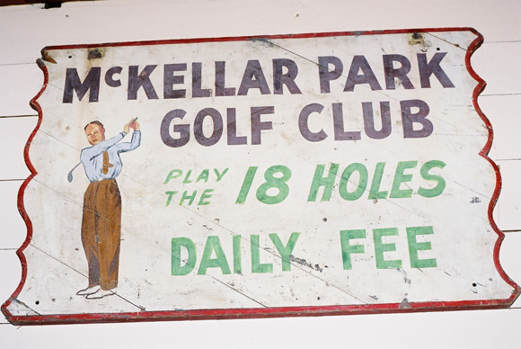
The original McKellar Park Golf Club sign (pictured at the top of this page) now hangs in the bar of Pine Lodge Resort in Bristol, Québec. There is a golf course at Pine Lodge and the previous owner, Charlie Russell, bought up some of the golf course equipment when McKellar Park Golf Club was closed in 1952. One rarely, if ever, sees the expression “Daily Fee” on a golf course, but during the 1930s, ‘40s, ‘50s and even the ‘60s it was commonplace. It meant that for that one price, one could play as many holes of golf as one had time or energy for. For the younger and less affluent golfer, it meant that they might be able to play 45 or 54 or even 63 holes in one day, for that flat rate of $1.00. The golf course sign also shows the golfer wearing a tie – common attire in the 1930s, but very rarely seen today!
Although the future looked bright for this golf club in the suburbs of Ottawa, the rosy outlook didn’t actually last very long. The Great Depression brought difficult financial times, both for the country and the neighbourhood. At this point in time the golf course was located in Nepean Township, and the Township came close to bankruptcy in the mid-1930s. The golf course survived the difficult 1930s and through the 1940s, but increasing taxes and demand for residential property brought the course to a close in 1952.
With luck, one might still find an old set of golf clubs at a garage sale with a member’s tag from the McKellar Park Golf Club. These tags – and the occasional golf ball that surfaces in someone’s garden – are great reminders of a slice of history in McKellar Park.
For those who are interested in further details of the history of the golf course, look up the fall 2008 issue of Flagstick Magazine for an article by Joe McLean, which can be found online in PDF format at flagstick.com.
Bob Grainger is a retired federal public servant with an avid interest in local history. KT readers may already know him through his book, Early days in Westboro Beach – Images and Reflections. He’s also part of the Woodroffe North history project and is currently working on the history of Champlain Park and Ottawa West. Do you have any memories to share about the McKellar Park golf course? If so we’d love to hear them! Email your feedback to stories@kitchissippi.com.