
This column is dedicated to the memory of a good friend, Grace (Waterman) Soubliere.
For the first half of the 20th century, there was a small community of houses along the Ottawa River at the very end of Mansfield Avenue. The only approach to this community was to follow Mansfield Avenue north from Richmond Road, proceed over the Canadian Pacific Railway mainline and then down to a street that paralleled the river. This street was called Banting Avenue. Today there are absolutely no visible traces of this neighbourhood – there is no sign that this was the site of a community of houses containing occupants who chose this out-of-the-way corner of the city and who cherished the advantages of living there. Sadly, with the passage of time, there are fewer and fewer people who have memories of growing up in this location.
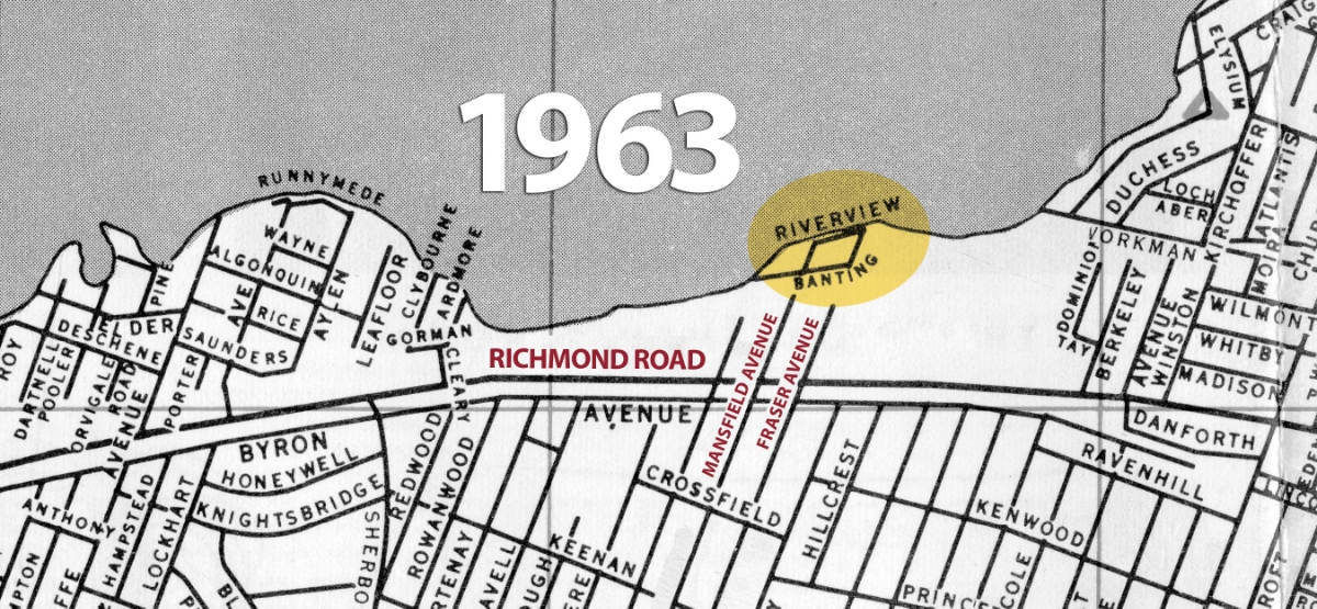
The map above shows a section of the Ottawa River shoreline from just west of Woodroffe Avenue on the west to Westboro Beach on the east. In the middle of this piece of the shoreline, one can find Banting Avenue at the point where Mansfield Avenue intersects the river. (The map also mentions “Riverview Avenue,” but this name was used less often.) Richmond Road is a prominent east-west feature, as is Byron Avenue.
The map was published by the Ottawa Tourist and Convention Bureau in 1963 at a critical point in the history of two railroads that ran through this area. The first of these is the Canadian Pacific mainline, which ran along the river between the shore and Richmond Road. Rail traffic along this line declined sharply in the 1960s, and by the end of the decade the rails and ties had been removed. The other rail feature that is missing from this map is the Ottawa Electric Railway. The Britannia Line paralleled Richmond Road, just a few yards to the south. The OER was terminated in 1959.
The disappearance of Banting Avenue is a small chapter in a larger story – that of the creation of the Ottawa River Parkway (now called the Sir John A. MacDonald Parkway). And the story of the creation of the SJAM Parkway is a small chapter in the larger story of the re-configuration of the City of Ottawa, which started with the meeting of Prime Minister Mackenzie King and renowned town planner Jacques Gréber at the World Exposition in Paris in 1937. King persuaded Gréber to come to Ottawa to offer his advice on ways to improve and modernize the face of the National Capital. This work was interrupted by the start of the Second World War but started again in 1945. One of the main thrusts of the Gréber Report was the creation of parkways, one of which was the Ottawa River Parkway. The creation of this particular Parkway by the Federal District Commission, starting in the late 1940s, required the expropriation of some 400 properties between Lebreton Flats in the east and the village of Woodroffe in the west. The neighbourhood of Banting Avenue disappeared under the Ottawa River Parkway.
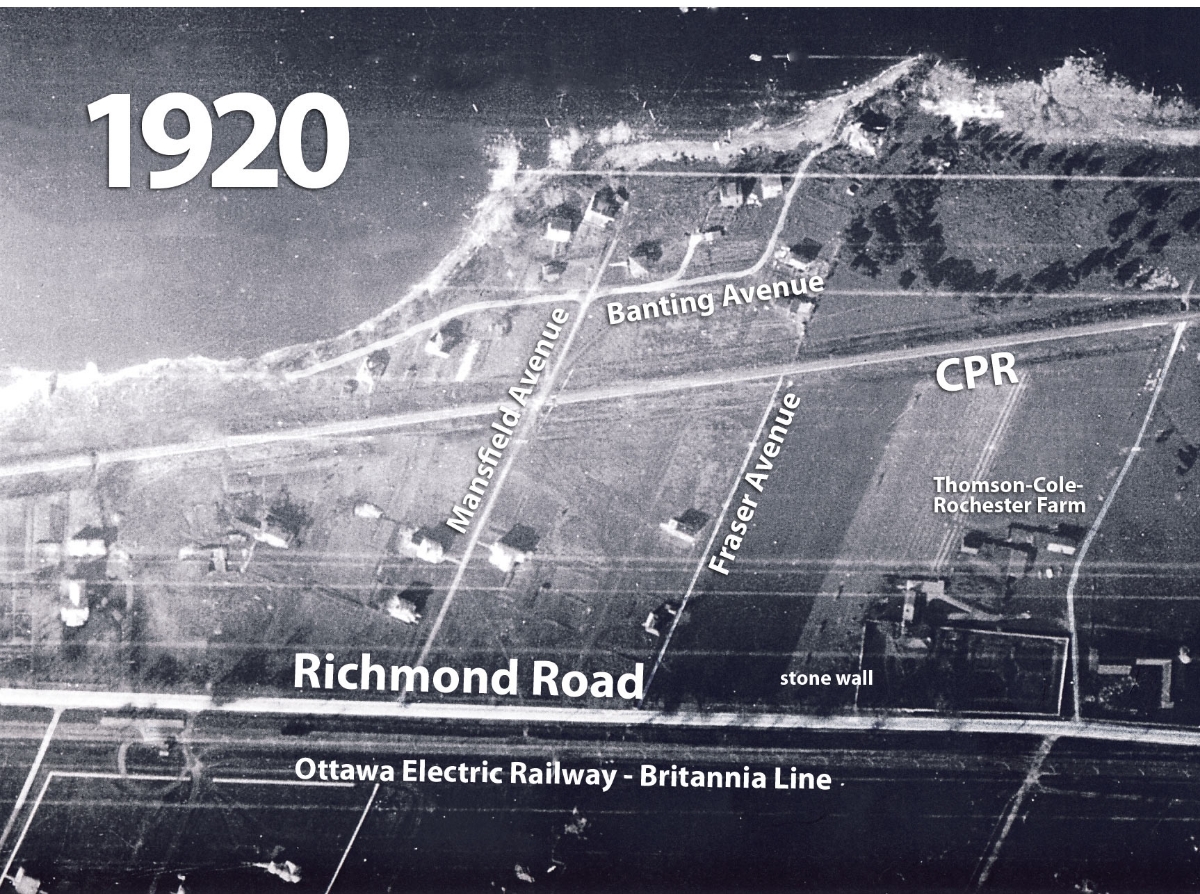
This air photo on the right was taken in 1920. (Click to enlarge it. As a sign of its age, there are several east-west trending scratches on the negative.) The river is along the top edge of the image. The rather prominent line across the photo about a quarter of the way up from the bottom is Richmond Road, with the two tracks of the Ottawa Electric Railway’s Britannia Line just below that. The conspicuous light-coloured line trending east-west through the middle of the image is the CPR railway. In the lower right-hand corner one can see the Thomson-Cole-Rochester farm with the barns and other out-buildings. Also quite visible is the rectangular stone wall which currently encloses the flower gardens of Maplelawn. (Interestingly, one can see a road immediately on the east or right-hand side of the walled garden, which leads back through an underpass under the CPR railway to several cottages on the shore of the river. There is a report of a YMCA camp in this area in the 1920s.) Proceeding west (or left) from the Rochester farm, one comes to a relatively little-used street – currently Fraser Avenue. A little further west one comes to Mansfield Avenue, obviously subjected to heavier and more frequent use, which crosses the railway tracks and leads down to Banting Avenue. In this photograph from 1920, it is possible to count 10 houses – this number would double by the mid-1940s.
Stay tuned next month for a more detailed look at the houses, and the people who lived on Banting Avenue.
Bob Grainger is a retired federal public servant with an avid interest in local history. KT readers may already know him through his book, Early Days in Westboro Beach – Images and Reflections. He’s also part of the Woodroffe North history project and is currently working on the history of Champlain Park and Ottawa West. Do you have any memories to share about Banting Avenue? If so we’d love to hear them! Send them to stories@kitchissippi.com.