
Kitchissippi has its share of busy intersections, but few are as rich in history as Wellington Street West at Holland Avenue. For the last 130 years and beyond, the neighbourhood has evolved around this junction of two important local roadways, and it is well worth a look at the fascinating history of these four corners.
What we know today as a bustling intersection was, in its earliest days, a quiet spot along Richmond Road in the middle of the Hinton family farm. Robert Hinton died in 1885, and Andrew Holland (a Hansard reporter, among many other endeavours) acquired the farm in 1887. He moved onto the property, but his true intention was to capitalize on the coming electric railway line. He had the area’s first phone installed in his home and tried different ways to make some extra money on his farm. He advertised for pasturage of cattle and horses ($2.00 and $2.50 per month, respectively), and pushed for the city to dispose of its “night soil” (the solid waste collected from outhouses and cesspools by city employees at night) on the farm. Carts would have travelled down Wellington and turned down a laneway to dump it on trenched fields in the area of what is now Holland just north of Carling. (Some uncomfortable history for modern-day residents to consider!)
In 1895, Andrew Holland and his real estate syndicate, the Ottawa Land Association, laid out a subdivision of the land between Parkdale and Harmer. Part of this included an extra-wide street (Holland Avenue), intended for streetcars. The streetcar had arrived as far west as Somerset Square that September, and just before winter, tracks were laid through Hintonburg along Wellington to Holland, then south to Carling and the Experimental Farm. The Ottawa Electric Railway began running streetcars on April 30, 1896, advertising a 15-minute run to Elgin Street, with cars every seven minutes. Three years later, the first sod was turned on Holland for the new Britannia streetcar line.
The area was still vacant land at this point. Even the old Hinton farmhouse, which would have been located just east of Holland, close to Byron, was demolished. Holland Avenue was an empty field with a double electric streetcar track through it, with a single line of posts placed between the tracks and poles branching out over the tracks to support the trolley wire. Eventually, this apparatus would be used for electric lights and telephone wires as well.
The first structure at the corner of Wellington and Holland was a small office the OLA built in 1896 to promote their property and lots.
In 1898, the first infrastructure in the area arrived by way of a drainage ditch down Holland to the Ottawa River. It was a first attempt to combat the menace of Cave Creek, and the spring runoff from all the area farms to the south and west. A trench was excavated and cedar-encased pipes installed. Other streets were gradually connected to the drain, but it would be 30 years until the area’s sewer issue was solved.
The first streetlight was installed to light the drainage ditch warning travellers of potential danger. It was a gas lantern with colored glass and was manually lit each evening. According to a newspaper report, a “light-headed and nimble-fingered rogue” stole it not long after its installation.
The first electric light was a single light connected to the larger Hintonburg system, which was installed in the summer of 1905 by the Stewart farmhouse at Julian, but was moved closer to Holland at the request of residents.
This was an era before cars, and so other than the bustle of streetcars passing through the neighbourhood, horse and carriage were the predominant method of transportation in the area. The village maintained Wellington Street and its plank sidewalks, but Holland was just a dirt path.
The OLA used the land to promote the sale of their lots. They held smaller auctions throughout the early 1900s, but most notable were two mammoth auctions in 1919 and 1920 to sell the 1,000 lots that make up Wellington Village. Huge circus tents were erected at the intersection to host the 1,500 bidders who purchased lots as cheap as $75. (You can read that column in our Early Days archives.)
Speaking of circus tents, the area between Wellington and Byron on the west side of Holland was the site of two huge circuses in June of 1912 and 1913. Ringling Brothers drew 45,000 people to two shows in 1912, while Barnum & Bailey eclipsed their success a year later, with a touring company of 1,200 people, 500 horses, 40 elephants, three giraffes, a rhinoceros and a hippopotamus. A street parade from Holland to Elgin Street and then back kicked off the day of excitement. The damage caused by the circus in 1912 led to Holland being paved for the first time soon after.
The Northwest corner
The first permanent building on the intersection was on the northwest corner. Prominent Hintonburg merchant Thomas A. Stott initially planned to build a small hotel, but he ended up building a residence. Construction was completed in July 1898, and it remained standing until 1954. It was briefly a Carleton Hardware Co. store (1913-1915), Lambert Eggens’ grocery store (1916-1919), and for nearly 30 years was David Rubin’s grocery store (1923-1951).
[Click photos to enlarge]
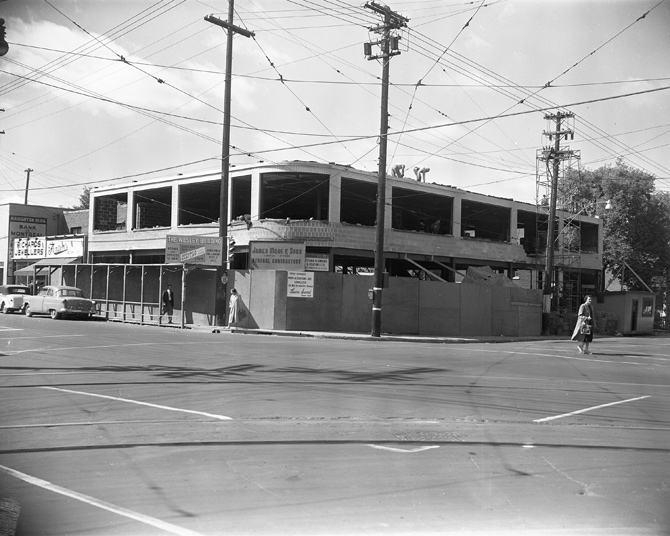
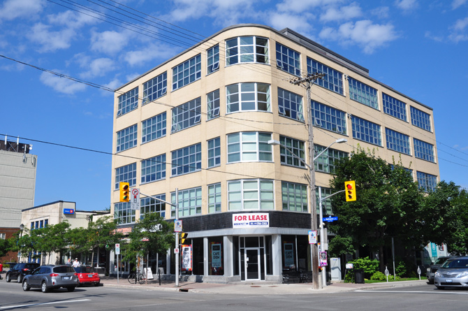
In 1955, the new “Wesley Building” was constructed at the cost of $225,000. Designed by architects Abra and Balharrie, it initially was just two storeys tall, but was constructed with the capacity to add up to three more storeys if required. Those three storeys were added in 1965. The original building contained Laura Secord’s chocolate shop, Henry Mack’s Men’s Store, and the Dictaphone Corporation on the main floor, plus offices on the second floor. Laura Secord’s is probably the best-remembered of this building’s shops, surviving until the mid-1990s. Skaff’s Restaurant, Martin Meinke Opticians, and Gift-O-Rama were other long-term tenants. In 1998, Routeburn Urban Developments purchased the deteriorating building and converted it into loft condominiums, retaining retail on the main floor. Until recently, World of Maps occupied the corner retail space, which now sits vacant.
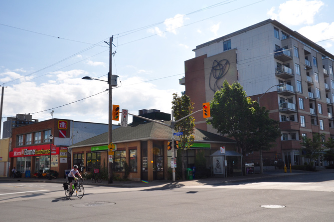
The Northeast corner
On Christmas Eve 1900, Hintonburg Reeve Jonas Bullman acquired this lot. The following spring, he began construction of a brick double house, with ground floor store. Bullman, for whom the Hintonburg street is named, ran a grocery store here until he died in 1917. Morris Feldberg (after immigrating from Poland and prior to later opening Morris Formal Wear) opened his first business here, a “cleaners and pressers” shop, from 1927 until 1934. It then became a shoe repair shop (“Modern Shoe Rebuilders”) from 1935 until its demolition in 1960.
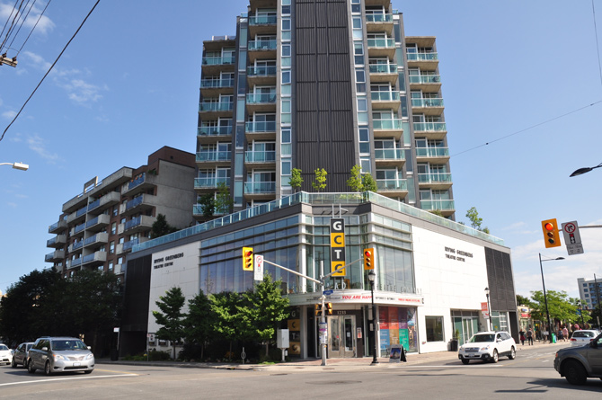
From 1961 until the mid-1970s, a B.P. gas station opened on the empty lot. From the late-1970s until about 1990, a dry cleaner was run out of the shop at the rear of the lot, which was taken over by Pro Shine Car Wash in 1992. The property briefly sat vacant in the new millennium before construction began in the fall of 2005 on Windmill Development’s 11-storey condo, the Currents, which features the GCTC’s Irving Greenberg Theatre.
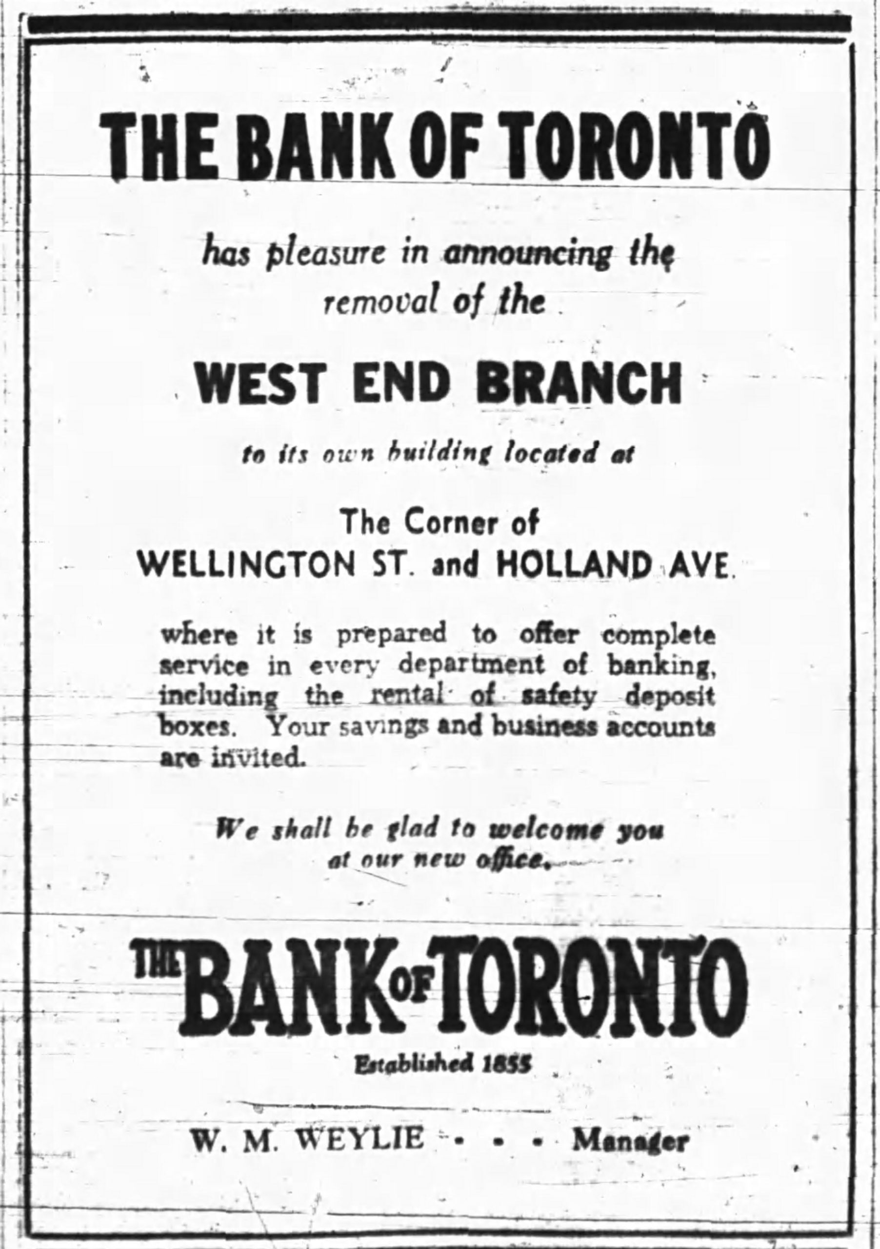
The Southwest corner
Readers may be surprised to discover the TD Bank has a history that goes back 80 years, to April 1937. It was originally a Bank of Toronto, but during the 1940s the building also housed the offices of well-known lawyer, W.E. Haughton and dentist William A. Wolfe. The original two 1/2 storey building was replaced by the current bank around 1970.
[Click photos to enlarge]
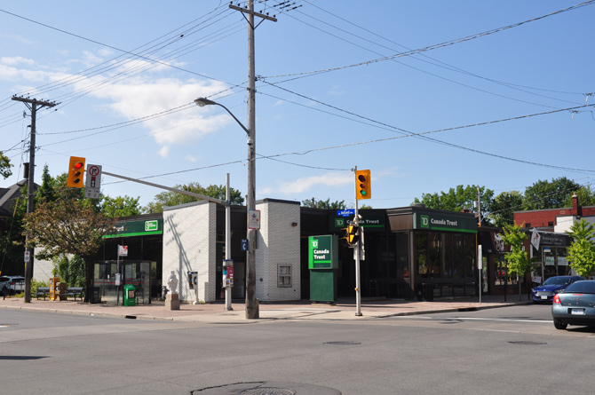
Before 1937, this corner was just a yard adjoining a home, owned by bible agent John McCullough, which stood from 1901-1940.
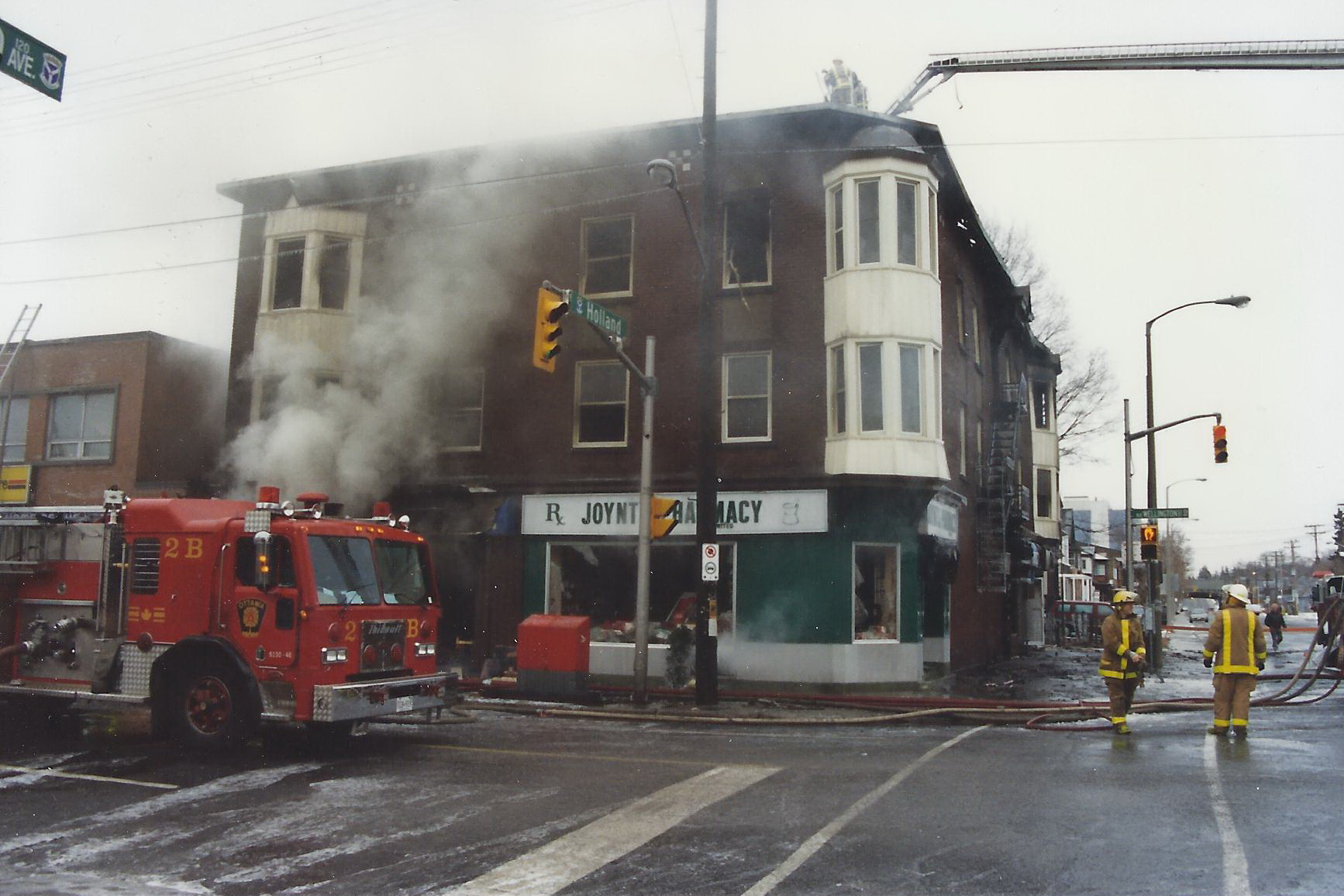
The Southeast corner
This corner was the last one to be developed and it was vacant until 1924. The only feature of the property throughout the first quarter of the 1900s was an advertising billboard that ran the length of the property along both Wellington and Holland.This was prime advertising space for passing streetcars, horse and buggies and the earliest automobiles.
Prominent westender and Magistrate for Carleton County, William Joynt, constructed the “Goldwyn Apartments” building, a three-storey brick structure that contained eight apartments on the top two floors and commercial spaces on the main floor. Most well-known was the corner pharmacy that was leased by Southwell, Garrison, and Nichols before William’s sons, Dalton and Walter Joynt, took over operation from 1939 to 1973. Their niece ran it until 1990, at which point it was sold and briefly became Joynt’s Pharmacy. The iconic building was torn down after a fire gutted it in December of 1996. In 2000, a new building opened on this spot, Simon Saab’s vegetarian restaurant, The Table, which remains a local favourite to this day.
[Click photos to enlarge]
Dave Allston is a local historian and the author of a blog called The Kitchissippi Museum. His family has lived in Kitchissippi for six generations. Do you have early photos or memories of the area? We’d love to hear them! Send your email to stories@ kitchissippi.com.