
Light rail will soon be arriving in Kitchissippi, changing not only the way the Transitway is used, but also providing expanded and improved transportation in and out of Tunney’s Pasture, a key hub on the forthcoming light-rail line (the western end of the “Confederation Line”). For many residents, even the Transitway itself is a relatively new development in the area. A little over 30 years have gone by in a flash. The Tunney’s Pasture bus station will soon be demolished, and railway tracks will be re-appearing.
Rail tracks sat on this very spot throughout the area’s development from isolated farmland to a thriving central Ottawa community. For over 110 years, the tracks separated neighbourhoods such as Mechanicsville, Champlain Park and Westboro Beach from their counterparts on the south. It was a true divide, but it was this same railway which spurred the first hamlets of growth in Kitchissippi.
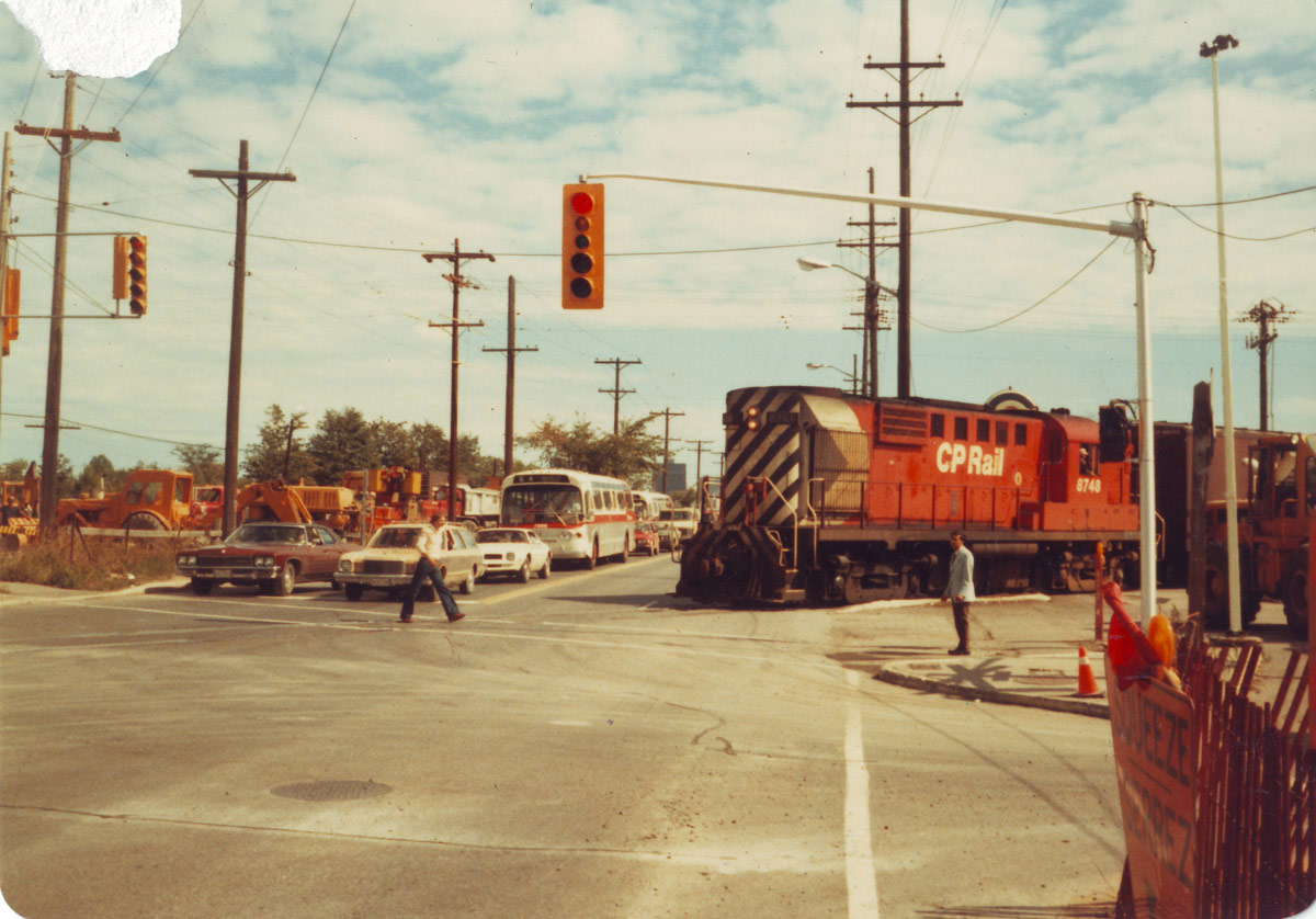
The Canada Central Railway ran their first train from LeBreton Flats to Carleton Place in September of 1870, and for more than a century, it was the norm to see the trains of the Canadian Pacific Railway (which took over the C.C.R. in 1881) running east to Ottawa and west to Carleton Place and beyond, with passenger trains stopping at Westboro station (on the south side of Workman Avenue, at the point where Kirchoffer intersects) and Ottawa West station (on the north side of Scott Street near Tom Brown Arena).
However, by the mid-20th century, trains were being phased out all across North America due to a shift in transportation planning, which saw governments prioritize the development of extensive highway and roadway networks. Railway companies went out of business, and the tracks pulled up under the belief that trains and streetcars were a thing of the past.
Scott Street was still only a small unpaved dusty lane until 1953, but by the 1970s, it had become a major roadway connecting downtown Ottawa to the west end. The Ottawa River Parkway first opened for traffic in December of 1963 (initially it ran only between Parkdale and Churchill), and the Queensway opened in 1964. For a time, these thoroughfares were able to handle the traffic to and from the west end.
The railway down Scott disappeared slowly. The last passenger train passed through Westboro station on July 30, 1966. The tracks along Scott were then abandoned in sections: west of McRae Street in 1967; west of Ross Avenue in September of 1970; and finally from Ross to Bayview on October 20, 1982 (it was kept open to serve Beach Foundry, the last customer on the line).
Talk of the need for an expanded bus network began in the 1970s, and approval was finally given by Regional Council in 1980. Even at the time, it was debated whether the right choice was being made to feature buses as the primary mode of mass transportation, versus light rail (Calgary had freshly installed their light rail system, which was hailed as truly modern and forward thinking; Ottawa saw it as too expensive and difficult to construct).
The City decided to use the former CPR right-of-way for the western section, with some additional land acquired along the route. Even some houses along the north side of the route had to be expropriated (including notably the original Napoli’s restaurant on Hinchey Avenue, which then moved to its current location on Richmond Road in August of 1983).
The blasting of Scott Street began in June 1983. By excavating the Transitway trench, buses would be hidden from sight and sound but nearby residents on both sides of Scott suffered through more than a year of constant drilling and truck noise, and many had damaged foundations, cracks in the walls, and broken windows. Regional government paid for repairs when the blasting was proven to be the cause. The blasting lasted until December of 1983 and then further construction work continued throughout 1984.
Being a 4-year-old resident of Cowley Avenue at the time, I have great memories of walking with my parents and grandparents to watch the construction of the Transitway from Premier Avenue (and the overpass at Carleton, which was a last-minute addition to the construction plans).
Station locations were selected at Lebreton, Tunney’s and Westboro to serve the neighbouring communities (though in the spring of 1984, some politicians – notably Mayor Marion Dewar – and many local residents opposed the idea of Westboro station, and there was serious talk of abandoning work which had already begun). Tunney’s was an obvious choice due to the government complex, though previously (unlike LeBreton and Westboro) there had never been a rail stop here. The only notable rail presence at Tunney’s was that the Beach Foundry on Spencer had utilized a rail siding that ran south across Scott at Holland, and up to the Foundry from the 1920s until 1982.
The Scott Street portion of the Transitway from Preston to the Parkway at Dominion opened on Remembrance Day of 1984. One thousand riders took a free trip on opening day to view the new route. When it finally opened, the bus shelters, staircases and lighting at all stations, including Tunney’s, were all temporary. The final structures were not added until the spring of 1985.
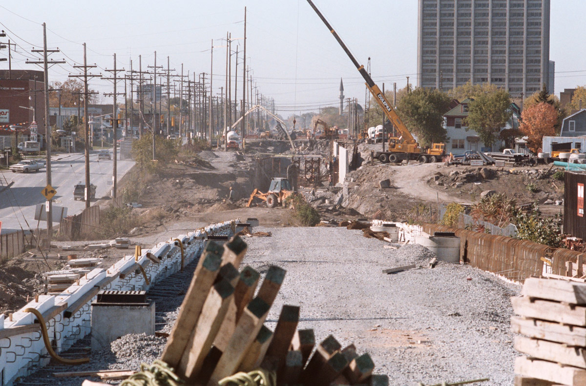
The construction of the Transitway ended up one of Ottawa’s biggest financial follies of all time. The project was initially approved in 1980 with a budget of $100M but the budget continually climbed, eventually doubling by 1983 and tripling by 1984. Once the complete original 31km section was finally complete in 1994, the total costs had run to $450M. Just the section along Scott Street from Preston to the Parkway cost $54M.
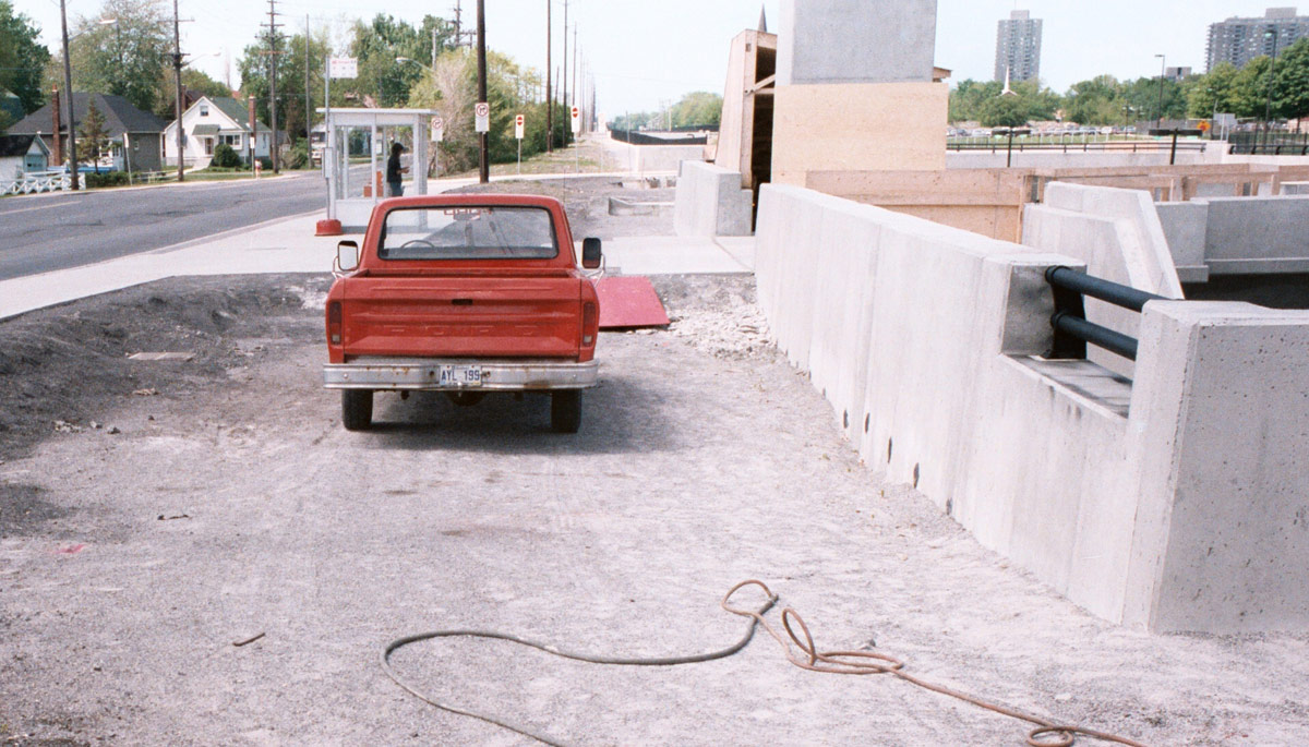
In the summer of 2016, construction will begin on the new Tunney’s Pasture station. It will be a hub for buses, trains and cyclists, and will feature a large pedestrian plaza with retail stores and public washrooms. It is scheduled to be completed in the fall of 2017. Longer term, the Tunney’s Pasture Master Plan projects the amount of office space to double with new buildings to complement those existing; with 90,000 square feet of retail; a major community park, as well as up to 3,700 new residential units. The station will become even more significant, and in another 30 years time, we’ll recall in equal disbelief the simplicity of the station which stood from 1984 to 2016, as we do in recalling that this spot once held little but one set of lonely tracks transporting previous generations through growing Kitchissippi.
Dave Allston is a local history buff who researches and writes house histories and also publishes a popular blog called The Kitchissippi Museum (kitchissippimuseum.blogspot.ca). His family has lived in Kitchissippi for six generations. Do you have any early memories of Tunney’s Pasture to share, or of Transitway construction? Send your email to us at stories@kitchissippi.com.