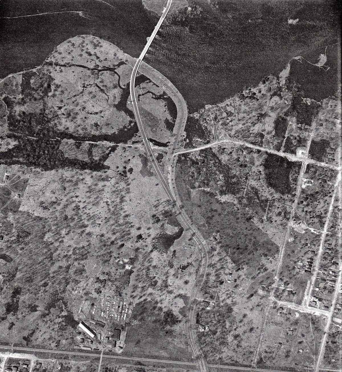
This photo was taken on May 5, 1933 and shows an area bounded by Carleton Avenue (visible in the lower right-hand corner), the Ottawa River across the top of the photo (with the newly completed Champlain Bridge), the Canadian Pacific Railway tracks across the bottom, and the eastern-most houses on Ferndale Avenue visible on the left-hand (or western) edge of the photo. And through the middle of the photo, dividing it into left and right halves, is the recently completed Federal District Commission Driveway, now known as Island Park Drive.
The photo was taken in the spring and the water level in the river was high, producing a lot of marshy ground in the area of the southern end of the Champlain Bridge. This area would later receive a very considerable amount of fill from the excavation of the Lord Elgin Hotel. After dumping their loads of fill, the trucks would pick up a load of elm trees for the median which ran down the middle of Elgin Street at that time.
Independent Coal and Lumber
The straight line along the lower edge of the photo is the Canadian Pacific Railway line. Halfway between Island Park Drive and the western edge of the photo along the railway is located Independent Coal and Lumber with their piles of lumber on the northern edge of the property. The entrance and exit for this lumberyard was Clifton Road, which shows up clearly on the photo. Delivery trucks from the lumberyard would cross the tracks and proceed south to Richmond Road. Scott Street was unavailable at this time. On the southern edge of the railway line is a very early version of Scott Street, more a trail than a street, and not open to vehicular traffic.
In 1933, the area to the west of Island Park Drive and north of the CPR railway line was open, scrubby forest (Magee’s Woods) all the way over to Churchill Avenue. There were a few houses on Ferndale Avenue, the two easternmost ones being visible along the left edge of the photo.
Riverside Park
To the east (or right) of Island Park Drive is the neighbourhood of Riverside Park, now known as Champlain Park. There are three reasonably developed and used north-south streets; Carleton Avenue in the lower right-hand corner, Cowley Avenue to the west, followed by Keyworth Avenue. In 1933, there is very little development of the land between Keyworth Avenue and Island Park Drive. There are also three east-west streets, starting with Sunnymede Avenue in the south, Clearview Avenue in the middle and Pontiac Street in the north. Pontiac Street is the only one to exit the neighbourhood to the west, ending in an intersection with the eastern approach to the Champlain Bridge.
The two approaches
This photograph shows two separate approaches to the Champlain Bridge. The right-hand (or eastern) one is the original one, and the only one shown on an earlier 1927 air photo. This original approach would have required Quebec-bound traffic to make a fairly serious left-hand turn just before the river, and then a sharp right-hand turn to get onto the bridge. Notice also that the original approach was wider, the same width as the FDC Driveway, with two lanes of traffic and a bridle path on each side for horses The later approach to the bridge did not incorporate room for bridle paths. The eastern approach was built to be a permanent roadway, because it included the classic lampposts, which characterize the rest of the Driveway. A piece of this original approach to the bridge still exists in the form of the parking lot, which is located just downstream from the present Champlain Bridge.
Here’s the question, why do you think were there two approaches to the bridge? Send your theories to stories@kitchissippi.com. Your comments may be included in the next issue.
Bob Grainger is a retired federal public servant with an avid interest in local history. KT readers may already know him through his book, Early days in Westboro Beach – Images and Reflections.He’s also part of the Woodroffe North history project and is currently working on the history of Champlain Park and Ottawa West. Do you have any tales to tell about the area? If so we’d love to hear them! Send your email to stories@kitchissippi.com.